Straight line walk - Summer 2004
In the summer of 2004 I performed a psychogeographic experiment. I picked a straight line from the grid of my well (ab-)used map of Rotterdam and tried to follow it as closely as possible. But the street layout of the city did not match the abstract grid of the map. And what should have been a straight line became a weird Nazca-line shape.

The line I followed is the line between the T and U vertical columns. I followed it from the 11 to the 13 vertical columns. Maybe I’ll extend it further North and South sometimes.

The walk starts at the Island of Brienenoord. This is a weird patch of wild nature dropped into the middle of the city. Many Rotterdammers don’t even know it exists.
This is the view North. To continue the walk I would have to cross the river. So I turn South.
I follow the semi hardened roads and admire the old infrastructure between the trees. I think this is a telephone switchbox.
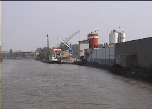
I cross the Hoendiep. Looking East I see the warehouses and sand silo's of the Zuid Diepje. Someday I want to float here with a rubber boat.
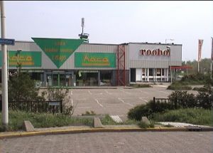
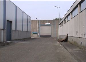
At the Stadionweg I enter a bland commercial area. Here are caravan dealerships, shops with building materials, storage providers etc. It's a very busy area. It is one of those chaotic fringe city areas where you can find new buildings alongside, busy highways and old neglected brownfields. A place for further research.
But my route takes me to the backside of the busy area and here is a small paradise for explorers. There is even one deserted building – unfortunately boarded up and inaccessible.
Next I have to cross the busy Stadionweg. It’s impossible to follow the straight line and I have to backtrack to the nearest pedestrian crossing.
I pass a Mc’Donalds a Shell pump and 10 minutes later I’m back at almost the same spot I came from. This is a very impersonal and bland – but therefore interesting part of Rotterdam.
Now I’ve left the commercial area behind and I enter an almost pastoral suburb, built in the 1940’s and spared by the German bombardment in WW II. It almost looks like England. Children play on the grass, people tend their gardens and starlings probe the lawns for worms. (Zuiderhelling, Sportsingel)
Then I leave the posh part of the suburb behind and enter an area that was meant as factory-worker’s houses. These are much smaller, but there are interesting mini-gardens and lots of nooks and crannies. All the streets have sport names. (Discus-, Floret-, Golfstraat)
Along the Stadionlaan I pass a few sports fields. Then I’m led onto the Buitendijk.
This dyke must be old – it has a curved trajectory and in earlier days it might have followed a small stream. I witness how a keeper lets a ball through. He is very unhappy.
In earlier times this must have been farmland. These house under the dyke look like old farmhouses. Still there is a field with goats, but these are just hobby-animals. Now it houses the Rotterdam Pet Crematorium.
I’m led along the Smeetslandseweg along an interesting city park with small pond. Then onto the wide Olympiaweg.
Finally I take the left-hand road - this is no photoshop, it really looks like that. (Grenskreek)
On my left hand are modern (1960-1970) apartment buildings and on my right hand a pen with sleeping ducks and turkeys.
Here the landscape turns extremely boring. Just functional 1970 houses, with bland gardens and some high-rise apartment buildings. How I hate the discipline of following a straight line – if it takes me into such uninteresting surroundings.
Fortunately some details are still interesting, like this colored band of tiles on an uninteresting building.

Or the personal collection of a fan of the Rotterdam football club: Feijenoord. (Peitkreek, Tonnekreek)

I'm led back to the Smeetslandseweg, and can see directly where my walk will end. But first I'm led back into the maze of back alleys and gardens (Kleinekreek, Sluiskreek)
Still the same uninteresting houses. You can find these all over Rotterdam. But for the inhabitans it must be a pleasant, village-like place to live. They even behave like villagers. I was stopped by an elderly man and questioned about what I was doing there.
Again I saw some interesting details like this football field and the (many) flags. It was some national holiday, I forgot which one. Maybe it was “The Queen’s day” or maybe a new princess was born.
And then, just as I thought it couldn’t get more boring – it got even more boring! Which was interesting … and thus not boring anymore.
Houses built in the 1980’s. These are the same all over The Netherlands. I might as well have been in a totally different city, I wouldn’t have noticed the difference. The same yellow old-bottle containers, the same mass parking places. Wow!
An empty field waiting to be developed. My map tells me that there used to be sports fields here.

They should always leave a few of these empty sport in the city, just for the variation.

Train station Lombardijen at my right hand and the busy Spinozaweg in front of me. My time was up and this was a natural boundary for my “straight line walk”. I had learned a few things:
  • random walks in the city can be very interesting,
  • but avoid living quarters of city that were built after 1960
  • stick to the river,
  • stick to the chaotic industrial sites,
  • even boring areas can be interesting if you walk with a purpose.
This is the continuation of the line southwards. I have not been here yet. According to the map the line should take me through hobby-gardens, across the rail tracks, through a weird industrial area (Hordijk), through some nature and finally across the highway and out of the city.

© Petr Kazil - August 2005
Adventure art - Buildering - Jan van der Meulen - Deserted - Underground - Remarkable - Curiosities - Ghosthunt - Graffiti - Borders